
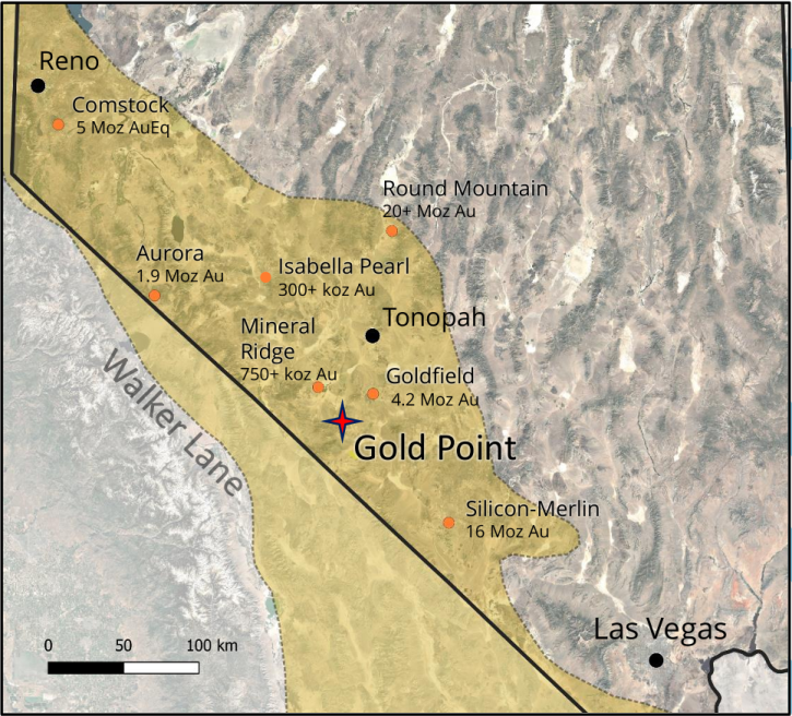
The Gold Point Project lies within the prolific Walker Lane Structural Corridor, a world-renowned region host to Tier 1 gold deposits.
GGL Resources recently consolidated the district for the fist time in its 140 year history.
Gold Point saw intermittent, high-grade past production (74 koz + Au) in the early 20th century, yet with no systematic modern exploration over the past 60+ years.
Orogenic, intrusion-related high-grade gold - mineralization likely continues to significant depth.
500 koz Au initial target proximal to historic mines, 1+ Moz Au target in step-out potential.
GGL Gold Point Corporate Presentation.
Project Summary
- Past-producing, high-grade gold district in Western Nevada with no modern, systematic exploration.
- High-grade gold with near-term resource estimation possible.
- est. 200,000 tonnes of mineralized material in exposed in known workings.
- Extensive underground workings with developed stopes in four past-producing mines on two major adjacent structures.
- Mineralization occurs within ore shoots in the district: primary production occurred on a single ore shoot which alone produced 55,000-65,000 oz @0.5-1.0 opt Au average grade, primarily before WW2.
- 6 Additional mineralized zones of similar magnitue and grade are priority exploration targets.
- 13 Additional veins within the system remain untested at depth and/or under cover.
- Mineralization remains open at depth (>300 m) and along strike greater than 5 km where most of the target zone is under cover.
Historical Highlights:
- Intermittent small scale mining between 1882 and 1962 produced an estimated 74,000 oz gold, primarily from a single ore shoot of the Orleans vein.
- Existing workings are mostly open and dry to approximately 275 m below surface on both the Orleans (1020’ level) and Great Western Veins (900’ level);
- Thirty-five historical samples collected post-mining across the Orleans Vein, from the 960’ to 1020’ levels, reportedly averaged 0.389 opt gold; and,
- Historical production records indicate recoveries between 92% to 98% for gold and 53% to 82% for silver, through cyanidation.
- Technical Report for the Gold Point Property
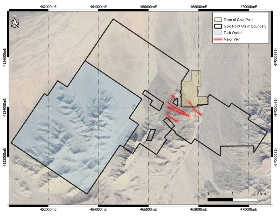
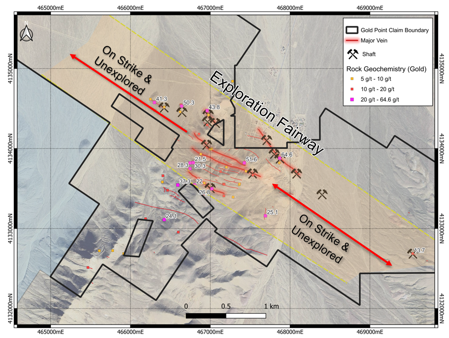
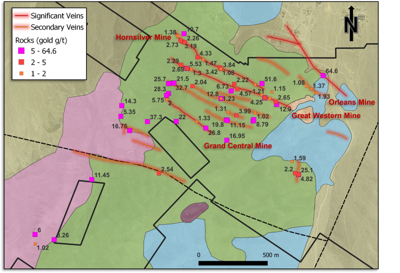
Gold Point District and Vicinity. The Gold Point project focuses on the primary veins (red) that host 4 major past-producing Au-Ag mines, and secondary, sub-parallel veins with smaller scale mines and workings. All veins remain virtually unexplored beyond mine workings, with 17 total outcropping veins known to be in the district. To the west-southwest lies the Le Champ copper-molybdenum porphyry target, optioned by Teck Resources Inc. from GGL in Fall 2024 with Drilling Planned for April 2025.
Consolidated District - A Historical First
- Since 2020, GGL moved to consolidate, and now effectively controls the Gold Point District for the first time in its 140 year history.
- GGL optioned the core of the current property in 2020 from Silver Range Resources and Nevada Rand LLC, and embarked on expansion and consolidation.
- The current land package totals ~7,800 acres, including 375 lode claims and 7 patented claims.
- GGL’s Gold Point Project now covers the four significant former mines (Orleans, Great Western, Hornsilver, Grand Central) plus numerous smaller mines and workings.
- Since 1962, various operators have sought to reopen the mines and revitalize the district; various claim positions and owners prevented advancing the district.
- No known systematic district-scale exploration has been conducted.
At least 17 significant mostly sub-parallel mineralized veins have been identified in the district primarily focused on a low-lying series of hills (central zone in figure). The majority of production at Gold Point Project was primarily from one vein, the Orleans vein, and to a lesser extent the Great Western vein. Along strike, the exploration fairway lies mostly under alluvial overburden.
Geology
Two Exploration Targets in the District:
- GGL Resources Gold Point - High-grade Gold-Silver Veins >10g/t gold occur in several shoots within a sub-parallel vein system.
- Teck Resources Inc. Le Champ Copper-molybdenum porphyry target currently under option, ~4km W-SW of Gold Point target. Drilling planned April 2025.
Mineralization
Gold Point High-grade Au-Ag mineralization occurs in shoots:
- Potential multi-phased, intrusion-related gold and silver mineralization (“mesothermal”); mineralization likely not depth-limited.
- High-grade shoots occur along a series of near-parallel, east-west striking veins.
- Shoots rake gently to the east, across the dip of the vein.
- Shoots range from 6’ to 40’ wide.
- The longest reported shoot extends for 320’ on the 600’ level of the Orleans vein system.
- Gold/Silver ratio increases with depth.
- Gold grades also increase with depth.
- Oxide mineralization in shoots has potential to continue to the water table, which has never been reached at depth (>1020’).
Orleans Mine (looking north)
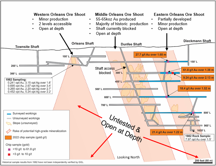
The three known ore shoots of the Orleans Vein, accessed by several shafts. The bulk of production occurred within the middle shoot with no down-plunged exploration. The two adjacents shoots arepartially developed and remain unexplored. All remain open at depth.
19 Known Veins Exposed at Gold Point
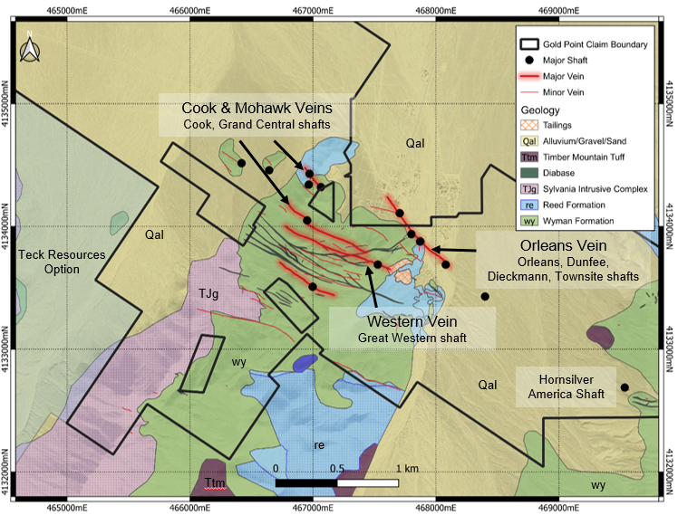
Several additional significant veins host several ore shoots each along the Western, Cook and Mohawk veins, and remain largely unexplored and are open at depth. Further opportunities exist with the 13 additional veins outcropping at surface that have minimal undeground workings and are likely open at depth.
Past Producing Veins
Orleans Vein (accessed via Orleans, Dunfee, Townsite and Diekmann Shafts)
- 55,000-65,000 oz Au historic production
- Traced underground for over 650m
- Development to 1020’ level
- Production to 960’ level
- Approximately 4,300m of lateral development
- Historic sampling:
- Lower-level samples (35 total) from the 900’ to 1020’ levels averaging 0.389 opt gold and 1.44 opt silver;
- A sample from a 0.5 m wide vein on the 1000’ level returning 7.97 opt gold; and
- 21 samples from the 600’ to 1020’ levels averaging 0.314 opt gold an 1.42 opt silver, including a chip sample across 1.22 m grading 2.15 opt gold and 1.78 opt silver.
- GGL Sampling (2023) included:
- 27.7 g/t gold & 63 g/t silver over 1.68 m from the 150’ level;
- 61.8 g/t gold & 71 g/t silver over 1.38 m from the 300’ level; and
- 9.24 g/t gold & 646 g/t silver over 2.13 from the 300’ level.
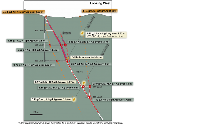
Great Western Vein (accessed via Western Shaft)
- 10,000-20,000 oz Au (est.) historic production
- Inclined Shaft to 920’ Level.
- Development to 600’ Level.
- Production to 400’ level.
- Vein traced for over 920m (surface and underground).
- Approximately 975m of lateral development.
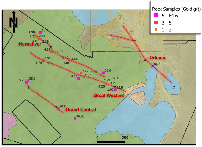
- GGL Sampling (2023) included:
- 23 g/t gold & 76 g/t silver over 1.3m from the 500’ level
Hornsilver (Lime Point)
- Traced for over 820m.
- Vertical shaft to 610’ Level.
- Future underground sampling planned.
Grand Central
- Surface trace exposed for 420m.
- Vertical shaft to 140’ Level.
- Approximately 150m of development.
- Future underground sampling planned.
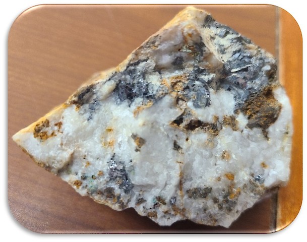
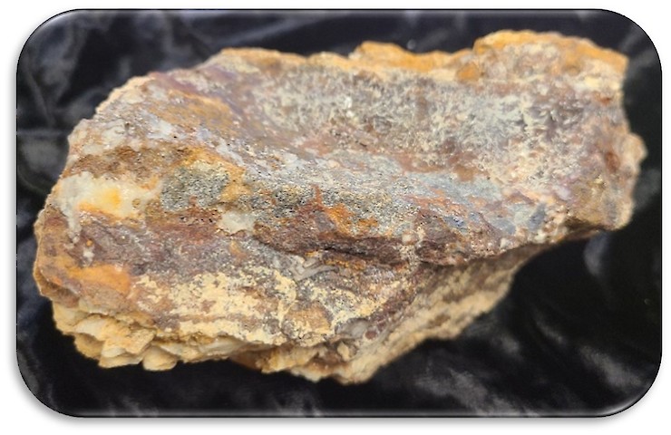
Typical styles of high-grade gold mineralization from the Orleans and Great Western Mines, Goldpoint, Nevada, grades >25g/t Au.
Great Western Mine Long Section (Looking South)
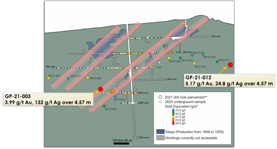
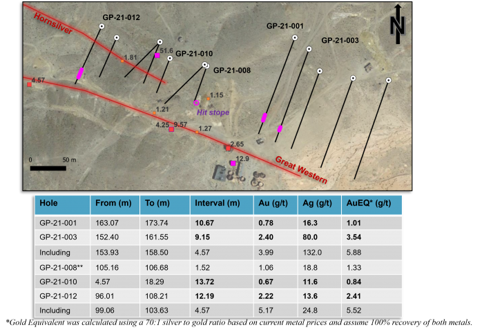
2021 Drilling - Select Highlights
Drill intersections - Gold
Drill intersections - Lead
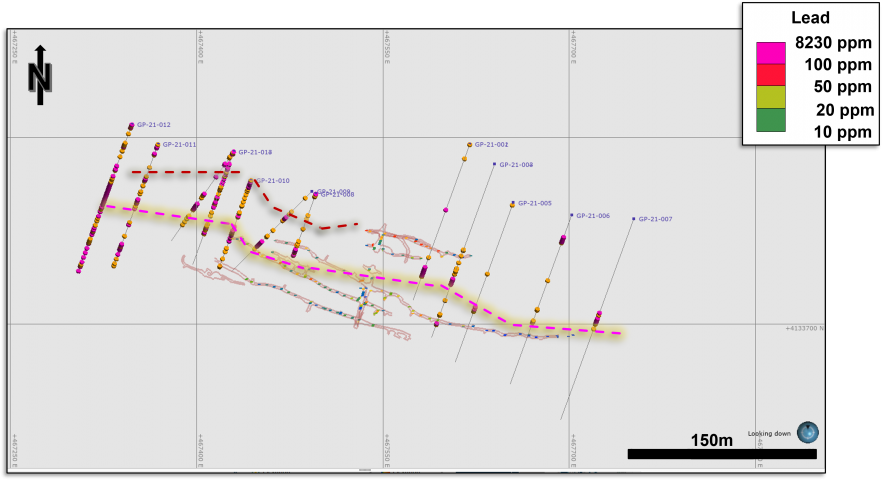
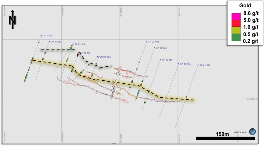
Generalized Cross Section
Other Veins and Targets
- 13 additional known secondary veins daylighting proximal to the 4 primary major historic production veins
- Northwest trending veins: a potential future target
- High-grade gold
- Breciated
- North-northeast trending: a later, follow-up target
- Predominantly silver-lead
- Lower-grade gold
- Unbrecciated bull-quartz common
Eastern Potential
- The eastern strike extension is covered by alluvium for approximately 2 km.
- Several showings and soil geochemical trends show that the veins continue to the east.
- The Dieckmann Fault marks the western edge of the alluvial cover and possibly offsets the veins.
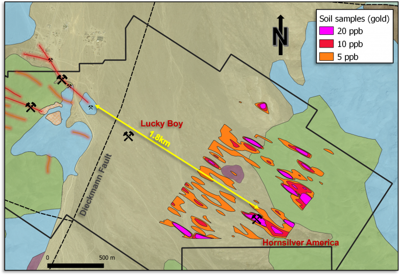
East Gold Point target area soil contours indicate potential seepage from minerlized structures may extend to the easternmost headframe at the Hornsilver America Shaft, where chip samples returned ~13g/t Au within the vein.
GGL Work Programs to Date
- Underground sampling at the Great Western Mine
- Surface prospecting and sampling
- Airborne magnetics and radiometrics
- Reverse circulation along the Great Western totaling 2,874 m (9,429’) in 15 holes
- Airborne radiometric and magnetics
- Ground magnetics and HLEM geophysics
- Soil sampling
- LiDAR survey

Future Fieldwork
- Underground rehabilitation of workings to allow for safe passage, potential underground definition drilling of ore shoots.
- Underground structural mapping and sampling at the Orleans and Great Western veins/mines.
- VLF and IP Surface geophysics along strike to the northwest and southeast of the known veins undercover for drill targeting.
- Airtrack drilling for fast, cost-effective step outs to potentially extend mineralized footprint of vein system at surface.
- Follow-up reverse circulation drilling targeting vein/shoot extensions on strike and undercover
- Extend soil sampling grids